Project Description
FROM AIA NATIONAL:
A river is only a small part of a large, inter-connected natural system involving various ecological and hydrological functions. It is in a constant state of flux and of vulnerability. Careless human actions have had detrimental effects on the Mississippi and its connected systems. These effects, however small in their individuality, may not be apparent immediately or even in the same vicinity. They are compounded as they move further downstream and impact individuals and ecosystems far removed from the source of contamination. This is why it is vital that we are conscious of our actions and understand their far-reaching impact.
A river is an ephemeral entity that is moving ever away from us, and with it, the potential to utilize and experience it on an emotional level. Because of this, we must tether ourselves to the river, as a way to inform our sense of identity.
Project Description
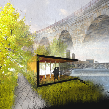
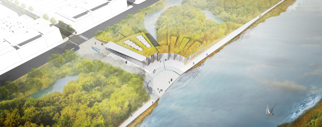
TETHER is a long-term urban renewal and environmental restoration effort located in the Hawthorne neighborhood of North Minneapolis. It seeks to repair the ecological and social fabric of the area, while creating educational opportunities and informing a sense of cultural identity strongly tied to the Mississippi River.
At the heart of this effort is an Environmental Research and Learning Center, occupying the site of a former concrete recycling facility. The building has three main functions which build off of one another: RESEARCH, TRANSLATE, and EDUCATE. 12,900 sf of research laboratories allow for water testing and environmental assessment of the river system. 10,900 sf of office space is provided for the Minnesota Center for Environmental Advocacy, which is a local organization that works with the legislature to enact sound environmental policy. 18,500 sf of public gallery, exhibit, and event space provides social and educational opportunities for residents to learn about the Mississippi river and its history within the city. Gross square footage of the building comes to 49,550 sf. Total square footage of the site, including a public plaza and wetland pond, comes to 109,800 sf.
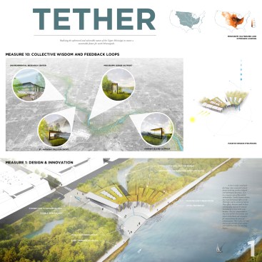
Measure 1 – Design and Innovation
The main goal of the project is to raise awareness of environmental issues within the Mississippi watershed through the programming of both the Research and Learning Center and the site, while creating a building that sensitively responds to its environmental and social context.
The building concept blurs the distinction between architecture and nature by developing a language of symbiosis, in which humans and nature can coexist. It is physically integrated within the restored oak savannah/wetlands and plays an integral role in the stormwater strategy of the site. The building mass buffers from winter winds and opens out to the south to maximize solar gains, while a double-skin façade helps regulate indoor temperatures and air quality. The program is organized around limiting energy use. The exhibit hall and offices, which need a generous amount of daylight, are located on the second level and take advantage of light scoops, while the event hall and research labs, needing a more controlled environment, are located on ground level.
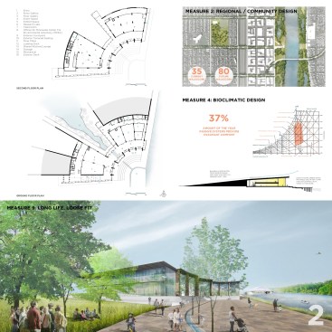
Measure 2 – Regional/Community Design
The site was chosen for its land use and socio-economic issues. The residents have long been cut off from the river by US Interstate 94 and a section of industrial land that has been becoming less economically viable in recent years. The development strategy centers around the following priorities:
1) The construction of a cultural building and plaza next to the river:
This provides a much-needed center for the community to gather, either informally or for large public events such as farmers markets and concerts.
2) Increase access to public transit, jobs and affordable housing:
Current walkscore for the site is 35, but projected to be around 80 with the proposed future development. This would provide a more sustainable framework for urban life in the area, giving residents the opportunity to live and work in close proximity, and lessen their reliance on automobile use.
3) Provide river access:
The proposal includes a series of pedestrian corridors that cross over I-94 and ultimately lead to the riverfront. The river and surrounding natural area, are used as learning tools which promote healthy lifestyles by connecting to the existing park and trail system, for which Minneapolis is well-known.
Measure 3 – Land Use and Site Ecology
The site lies within the Mississippi watershed, the largest drainage system in North America (4th largest in the world) and touches 31 US states and 2 Canadian provinces. More than 50 major cities, including Minneapolis, rely heavily on the Mississippi for drinking water and yet it is still polluted due to agricultural and urban run-off. The pollution levels have gotten to the point where they have created an ever-growing dead zone in the Gulf of Mexico, which is one of the largest in the world.
The programming of both the site and building seek to mitigate this issue. It restores the damage done to the site by its industrial past, and returns it to a ‘performative’ environment that provides a place where natural vegetation, wildlife, and humans can coexist. It creates and maintains on-site ecosystems for native wetland plants and animals to thrive, while also tapping into a regional network of open spaces that are important in the migratory patterns of various bird species, including the bald eagle.
Measure 4 – Bioclimatic Design
Minneapolis falls in ASHRAE’s Climate Zone 6 and is characterized by significant temperature swings from winter to summer. Winter low temperatures are the main concern because they are usually coupled with high wind speeds. Summers can be very hot, but are less of a concern because they are short.
Using Climate Consultant to evaluate bioclimatic conditions in Minneapolis, weather conditions are within the human comfort level only 10% of the year. However, using passive systems such as solar heat gain and natural ventilation can increase this number to 37%. This still necessitates the need for active systems for the remaining 63% of the year however, utilizing passive systems can significantly lower overall energy use.
The building massing and fenestration has been designed to deflect prevailing NW winter winds while opening out to the south. This maximizes solar gains in the winter, as well as views to the river and surrounding area. The NW façade has minimal glazing (except for skylights) and is largely buried into the earth. In doing this, the building utilizes the relatively warm temperature of the soil in the winter months to reduce the energy needed to heat the building.
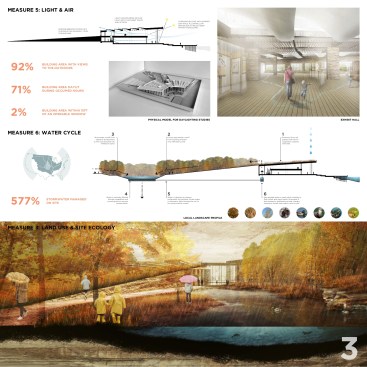
Measure 5 – Light and Air
Due to the building’s position within the landscape, getting light and air to the occupants became a design concern. During early programming studies, it became clear that daylight was driving the organization of the interior spaces. Support spaces moved to the NW perimeter while the most active spaces were pulled to the south and east. The building is organized around a radial series of sandstone walls which provide a clear spatial identity and orient visitors to the river through long, unobstructed views. Because of this, 92% of the floor area of the building has views to the outdoors. Skylights on the upper level bring additional daylight to the exhibit hall and offices. Overall, 71 % of the building can be entirely daylit during occupied hours.
The double-skin façade acts as an air intake, bringing fresh air into the building’s mechanical system and improving indoor air quality. There are intentionally few user-operated windows because the amount of time throughout the year in which passive cooling is beneficial, is very short. However, operable windows do occur in the second level offices. Because of this, only 2.1% of the total floor area is within 15’ of an operable window.
Measure 6 – Water Cycle
The building’s water cycle utilizes the natural hydrology of the site. A series of stormwater detention ponds scattered throughout the oak savannah use biofiltration to naturally treat runoff and graywater from the building, potentially reducing the building’s water use by 50%. Minneapolis gets an average of 28.3 in of precipitation per year, with a 24hr 2-year event value of 2.3 in. The detention pond to the north of the building has the capacity to store and treat approximately 101,000 cubic ft of water, or 577% of building and site runoff. This means that it can also treat a significant amount of runoff from the surrounding urban environment. Once filtered, the water either infiltrates the soil and restores groundwater supplies, or is captured in cisterns beneath the building where it is used for non-potable functions such as flushing toilets and washing hands.
Measure 7 – Energy Flows and Energy Future
The building uses both passive and active systems to minimize energy use, including berming up to the NW wall of the building, maximizing daylight, and the use of a double-skin façade. This façade helps to passively cool the building in the summer by allowing in breezes, and passively heat the building in winter by capturing solar heat and pumping it to other parts of the building through the mechanical system. It also utilizes a geothermal heat pump (GHP) system which takes advantage of the earth’s stable 54° temperature 10 ft below the frost line. Using a vertical closed-loop system (as opposed to a horizontal system) greatly minimizes the disturbance of the surrounding site during construction.
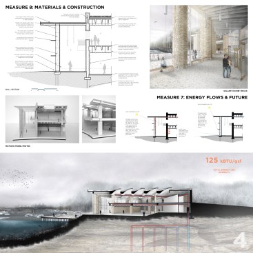
Using eQuest to create a basic energy model for the building, the Energy Use Intensity (EUI) is 125 kBTU/gsf. not including the energy saved using the GHP system. Through energy modeling, I learned that there are infinite variables that can affect the efficiency of a building. The only definitive test is a post-occupancy evaluation. These should be common practice, as they hold buildings accountable for their actual energy use, and drive the standard for more energy efficient buildings.
Measure 8 – Materials and Construction
Sandstone and concrete are the primary building materials. They were both chosen for their durability and their proximity to the site. The structural frame is concrete, with the bearing walls and piers clad in local sandstone. This sandstone increases the thickness of the mass walls and increases the potential thermal energy storage. It also conceptually ties the building back to the site, as the natural geologic formations in this area of the Mississippi river consists of striated layers of sandstone and limestone. The sandstone can be mined in nearby quarries, which minimizes the overall carbon footprint of the material by reducing its reliance on large amounts of fossil fuels needed to transport it to the site. This being an active public building, the selection of durable materials will ensure low maintenance costs and a longer overall lifespan than a building using an alternative structural system such as timber.
Measure 9 – Long Life, Loose Fit
In a neighborhood that is constantly shifting demographically, the research and learning center is designed to be a place of timelessness: a constant part of life in North Minneapolis that links its residents to the Mississippi River’s past, present, and future. It is to be a place of social connection and cultural identity, and a symbol of acceptance of all people. The use of local sandstone adds to the timelessness and solidity of the building, rooting it in the natural geologic forces of the site.
Measure 10 – Collective Wisdom and Feedback Loops
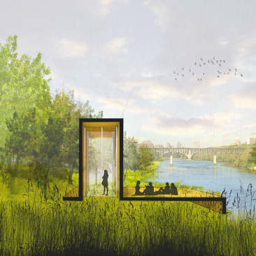
The impact of the building is spread beyond the site through the placement of 3 small outposts located at key points along the river as it flows through Minneapolis and St. Paul. Accessed by the existing walking and biking trails, each outpost offers a moment of re-connection and appreciation for the incredible variation of the river’s character while educating visitors about environmental issues. The first is located at St. Anthony Falls in downtown Minneapolis, (the largest waterfall on the Mississippi) the second is located at Mississippi Gorge Regional Park, (characterized by 100 ft tall sandstone bluffs) and the third at Harriet Island in St. Paul which is prone to flooding every spring.
Each site contains a water quality meter showing current pollution levels so that the community can be actively engaged with the health of their river. This reinforces the reality that we are not removed from our effects on the natural environment, and must understand that our cities should be designed in an ecologically sustainable and socially-conscious manner.
Faculty Sponsor: Gerald Gast