It’s been called the “High Line effect,” and it’s stronger than ever. Fifteen years ago, the idea of redeveloping a city’s obsolete infrastructure into a photogenic public amenity wasn’t at the forefront of any urban planner’s mind.
Today, following the success of the blockbuster 1.45-mile-long elevated park in Manhattan, nearly every major city in the country is eyeing its abandoned or underutilized rail lines, airfields, and industrial waterfronts in hopes of transforming them into places that people will want to visit. The large scale and rapid pace of these transformations, however, can be whiplash-inducing.
The High Line, which opened to the public in 2009 after being fought for by high-profile advocates like Diane Von Furstenberg, has been praised as an icon of contemporary landscape architecture, but it has also been criticized as an example of what can happen when big money enters a public space equation. A Jan. 7 New York Magazine article by architecture critic Justin Davidson described the High Line as an “elevated cattle chute for tourists … squeezed between high glass walls and luxury guard towers.” It has ushered in a boom era for development on the surrounding blocks, and it was visited by an estimated 8 million people in 2016. High Line designers James Corner Field Operations and Diller Scofidio + Renfro are spearheading a third phase of the project slated to open later this year.
“We wanted to do it for the neighborhood,” High Line co-founder Robert Hammond told CityLab in 2017. “Ultimately, we failed.”
Hoping to rectify some of the High Line’s mistakes, Hammond’s latest project is the High Line Network, a group of 19 ideologically united infrastructure-reuse projects across the United States and Canada. Heralded as the “next generation of public spaces,” the 19 projects have the shared goal of harnessing the “transformative potential” of underutilized urban places. Some projects have already been completed, and some are still in progress. Ideally, all hope to better their cities without displacing long-time residents.
“We want to make sure that we create this common ground around the impacts and the benefits of these projects,” says Ana Krejcarek, a manager at the High Line Network. “How can we make sure that it’s an equitable process?”
Who Is The Space For?
The 11th Street Bridge Park in Washington, D.C., is on track to become the city’s first elevated public park. At the center of the plans lies a strong intentional approach to the ways in which it plans to serve the adjacent community in the process.
Scott Kratz, the 11th Street Bridge Park’s executive director, says that after a 2014 design competition to formulate a vision of what the park could look like, “we started asking ourselves, internally, what role we could play in investing not only in this park, but also in the broader neighborhood.”
The park is slated to be completed by 2023. Located on the piers of a former freeway bridge spanning the Anacostia River, it will serve as a literal and symbolic connection between the more affluent neighborhoods of Navy Yard and Capitol Hill to the west and Anacostia and Congress Heights to the east. “It became very clear that we had a unique opportunity to play this role as a convener, to see what we could do,” Kratz says. Communities “east of the river” have historically received less economic investment than other parts of the city, and access to fresh produce and healthy food is a major concern for many of their residents.
Kratz is acutely aware that a project like the 11th Street Bridge Park has the potential to bring change to the area—but he wants it to happen in a way that will, first and foremost, benefit the people who already live there. Once it’s finished, the park will include outdoor performance spaces, playgrounds, public art, urban agriculture, and more. Hundreds of hours of community meetings have attempted to focus on the priorities of existing members of the neighborhood.
“It [the development] needs to be community-driven, we need to have this level of intentionality; and perhaps most importantly, we need to be thinking about this early,” he says. “Once the market really starts to move, it’s going to move much faster than we can possibly respond to it.”
The park, which is estimated to cost $45 million, released a set of equitable development goals in 2015 emphasizing job creation and affordable housing. Strategies include tenants’ rights workshops, a home buyers’ club and a community land trust. The park’s nonprofit arm is also buying property in the neighborhood with the intention of creating below-market-rate housing.
“It’s been an iterative process to identify where the needs are,” Kratz says. “There’s an enormous amount of economic pressure that’s about to jump across the river. And this was really the last chance, I think—not to be alarmist—but this is the last chance to really get it right in D.C.”
Context Matters
In Detroit, a city with a history of low urban density and disinvestment following the decline of the auto industry, there was an acute need for a public space that would give residents a safe place to congregate, exercise, and spend time outside.
“Detroit is very spread out, and we don’t have a strong network of pathways that bring people together,” says Mark Wallace, president and CEO of the Detroit RiverFront Conservancy. The Conservancy owns and maintains the Dequindre Cut, a High Line Network project that is a two-mile trail along a former Grand Trunk Railroad line.
Designed by SmithGroup, the first section of the Dequindre Cut opened in 2009 as a predominantly below-street-level greenway accented by urban artwork and graffiti. “For us, a place where families can be safe and kids can make memories like that is really important to restore community,” Wallace says.
The Cut is different things to different people. To some, it’s a bicycle-friendly transportation alternative. To others, it’s a park or public safety infrastructure. “It really functions as all of those things, which is what makes it special,” Wallace says. “It’s become a place where people can interact with nature in a very different way. In the Dequindre Cut, people can, literally, escape the hustle and bustle of a very urban environment.” According to a recent intercept survey, about half of the visitors to the Cut are Detroit residents.
While Wallace acknowledges that the Detroit RiverWalk (which opened in 2005, with almost 4 miles of the 5.5-mile vision currently complete), in tandem with the Dequindre Cut, has spurred real estate development in the surrounding areas, the Conservancy is committed to maintaining the riverfront as a public space as much as possible. A more recent project, the Dequindre Cut Freight Yard, repurposed nine shipping containers for use by food and beverage vendors from the months of May to September, providing a spot for walkers and bikers to rest, refuel, and socialize.
The High Line Network, Wallace says, has been a “tremendous resource.” “It’s great to have an opportunity to talk to peers in real time who are interested in the same topics, and trying to find solutions to similar issues,” he says. “It’s been really great to have that cohort pull together.”
Controlling the Ripple Effect
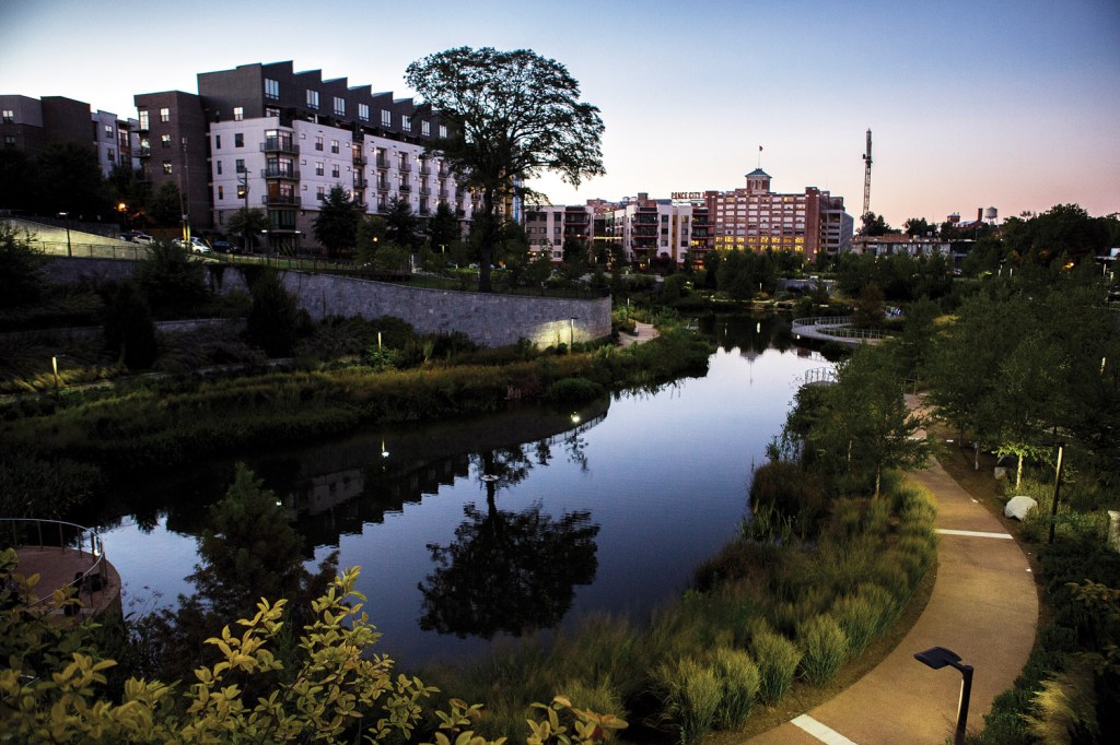
In Atlanta, where the more extensive 22-mile Beltline project has been expanding in increments since 2008 (predating the High Line by a year), there has been a bit more backlash surrounding the new development spurred by the planned loop of parks, trails, and transit. (Atlanta Beltline, Inc., the development’s parent company, is aiming to complete the project, including a light rail component, by 2030.) In July 2018, hundreds of protesters picketed downtown Atlanta, decrying the rising cost of housing near the Beltline. At the time of its founding, the Beltline committed to creating 5,600 units of affordable housing by the time of its completion. As of 2017, according to the Atlanta Journal-Constitution, it had only funded 785.
Despite these local controversies, the Beltline is booming, attracting an estimated 2 million visitors annually. “What started out as kind of an Atlanta destination for walking or moving between neighborhoods, or bike commuting, has turned into a tourist destination for people across the state and across the country,” says the Beltline’s media relations manager Jenny Odom. She emphasizes that the Beltline tries to address affordability as “a bigger picture,” of which there are three pillars: housing, job opportunities and job training, and transit.
“Transit creates those connections to jobs,” she says. “So between transit, jobs, and housing, those goals are what we aim for to create affordability in Atlanta.”
The High Line Network convened in Atlanta at the beginning of December 2018, and Odom says that talking about the connections and shared challenges between each of the projects is helpful in strategizing solutions.
“Everyone is having an affordability crisis of some kind,” she says. “Projects like this spur desirability, and spur an increase in property values. I think everyone is cognizant of that and wants to mitigate that and put those tools in place.”


