For Real
The University of Minnesota Virtual Reality Design Lab (VRDL) recently installed a VR system in Rapson Hall, where the schools of architecture and landscape architecture reside. The brainchild of architecture associate professor Lee Anderson, the VRDL platform allows multiple users to experience immersive, stereoscopic VR while roaming about Rapson Courtyard with wireless headsets. The platform offers more than 900 square feet of tracked area with room to grow. “We’re pushing the boundaries in several areas, including the size of the space that we’re using, which is really big for a virtual reality system,” Anderson told the Minnesota Daily.
Remember the hype around virtual reality? The movement to create digitally constructed environments that stand in for real experiences took off in the 1990s with the development of computing technologies and gaming software. For architects looking to communicate their designs with greater realism, an immersive, stereoscopic visualization technique holds much appeal. However, virtual reality (VR) has been cumbersome to implement; VR labs often rely on the Cave Automatic Virtual Environment model—a small enclosure that limits the experience to one person at a time. Consequently, not many people have been seen wearing VR headsets lately.
But VR is far from extinct—in fact, it’s finally gaining traction, garnering increased interest from Hollywood as well as the military, aerospace, medical, and gaming industries. The proliferation of mobile computing, wireless, and GPS technologies has enabled VR to escape the lab. Now, architects can use VR as a productive, on-the-go tool, untethered from the cumbersome hardware of the past.
GPS-enabled mobile electronic platforms on tablet computers or smartphones can simulate a live, digital “slice” of another environment—like a mobile aperture depicting an alternate world. The most compelling VR applications augment reality, layering invisible or simulated data onto the visible world.
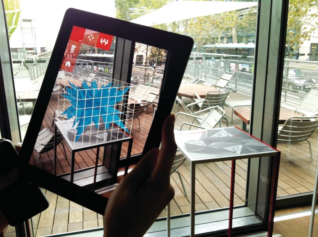
The French company Urbasee has released two such architectural applications. Urbasee Project brings 2D drawings to life, tethering virtual models to tabletop plans for enhanced design meetings. Meanwhile, Urbasee Future superimposes virtual building models to scale onto their proposed sites. Both programs require KMZ-format georeferenced files, such as those produced by SketchUp. Otherwise, the tools are ready to go—no headset or cables required.
These aperture-style VR tools do not provide stereoscopic immersion, but the development of wireless technologies that can deliver large amounts of real-time data has enabled the first generation of full-immersion VR systems in a semi-mobile format. At the University of Minnesota, where I teach, faculty in the College of Design and the Digital Design Consortium have developed such a tool (see “For Real,” at right).
Despite their capabilities, the tablet and wireless VR-based tools have their limitations, including seamless tracking. In my experience, the smoothness of Urbasee’s operation varies with the strength of the GPS signal. The University of Minnesota VR tool also has time-delays in its delivery of wireless data—a problem that the team is currently troubleshooting.
Economics is another challenge. While the visualization of one project is free, Urbasee charges more than $1,000 per year for additional projects. Although the Minnesota system is free for university faculty, staff, and students for educational purposes, non-university entities must pay a resource fee.
Nevertheless, these approaches demonstrate the extent to which VR—now freed from the dark recesses of the cave—is becoming significantly more accessible and publicly visible. Soon, we may all be stepping into our designs.