By
drawing on the practice of railbanking—the repurposing of abandoned rail
corridors into recreational trails—McLain Clutter, director of the Ann Arbor, Mich.–based design and
research practice Master of None, hopes to end the notion of living on the
wrong side of the tracks. Clutter, also an assistant professor at the University of Michigan Taubman College of Architecture and Urban Planning, and his research assistant Sehee Kim are using geographic information systems (GIS) to manipulate and repackage
geodemographic data in an effort to transform Detroit’s rail corridors into public
spaces that bring together residents with different socioeconomic, ethnic, religious, and
racial backgrounds. “This project points toward the use of data as a design
medium for designers … to instigate the possibility of new kinds of
collectives in the city,” Clutter says.
Historically, Eastern European communities and African American communities in Detroit have developed on opposite sides of the rails. As the city’s industrial activity declined, the sprawling lots of former factories that once lined these tracks have further segregated the neighborhoods.
When considering how to address these and other developable properties across the country, real-estate investors are increasingly examining geodemographic data using GIS. But their approach, Clutter says, often reinforces stereotypes about race, ethnicity, religion, and income level and thus deepens divisions between communities. For instance, he says, they might add a Walmart in a location based on preconceived notions about socioeconomics and race. Though the international chain retailer is likely looking for “a sophisticated and ‘designed’ mix of demographics” when considering a site, he adds, “we can probably assume that relatively low-income consumers within the catchment are desired, and that those consumers are sometimes minorities.”
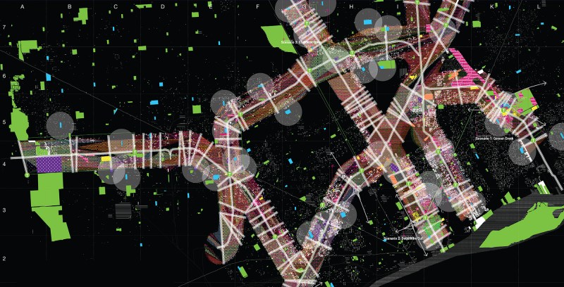
Instead, Clutter appropriates the data imaging tools that city planners typically
use to implement zoning policy from Esri, the world’s largest
producer of GIS software, and mixes in demographic data from the U.S. Census
Bureau and other public sources. He applies his own scripts and models to re-cut the data and find the areas with the
most intense population-density values. These regions are isolated and
re-grafted to serve as the basis for a second set of models, interpolating a
series of demographic values. Through continued analysis, these second-generation models isolate the most intense slope values, which represent the areas with the greatest potential for change. These subsequent maps are by nature graphic and visually illustrate new types of urban environments in these areas, whereas more conventionally constructed maps simply depict existing geodemographic data.
For example, when evaluating how to develop the sprawling lots where mortar production factories once stood along the railway in the northwest Detroit neighborhood of Conner Creek, a Radical Railbanking zoning map recommends introducing religious institutions, production centers, civic infrastructure, a transit center, and parks to create a commons that causes existing enclaves and neighborhood populations to intermingle.
Juror Joyce Hwang said she enjoyed the way Clutter
“misused” existing technology and data to develop the maps. “This project uses GIS in a
thought-provoking, unconventional, and almost delirious kind of way,” she said.
See all the 2015 R+D Award winners here.
Project Credits
Special Thanks: Syracuse University School of Architecture—Mark Linder