Courtesy College of Computing, Georgia Institute of Technology
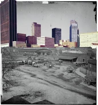
Built in 1913 for Joel Hurt, an early Atlanta developer, the Hurt Building is a cornerstone of the city’s downtown. Architect J.E.R. Carpenter’s grand design is sited on a broad, triangular parcel, and, at the time of its construction, it was one of the largest office buildings in the world. But for Frank Dellaert, associate professor in the College of Computing at the Georgia Institute of Technology in Atlanta, this isn’t why the structure is important. It’s the height. At 17 stories, the building’s roof offered a sweeping perspective of the city. Over the years, photographers routinely lugged their equipment to the parapet and captured Atlanta on film.
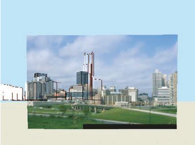
Dellaert and his research team—which includes Grant Schindler and Sing Bing Kang of Microsoft Research—are at work on “4D Cities.” The project adds time as a variable to 3-D urban models, creating an image database that shows a city’s evolution. Like a kind of virtual time-lapse film, it’s an interactive way of accessing historical image archives.
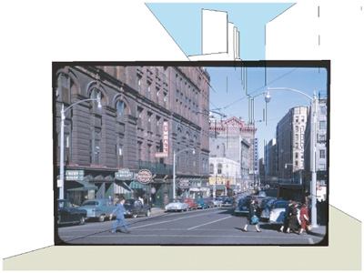
To illustrate their software developments, the team has built a 4-D model of Atlanta using contemporary digital data and historical documents taken from the Atlanta History Center’s archive. Dellaert calls it “photographic archaeology.” The photographic record is used to shape the model, a process called “spatio-temporal reconstruction.” The team fed some 200 images into the system to build the sample model. Determining the camera lens position is just as important as the subject matter it captured. Each locus gives the computer a vantage point from which it can identify where the buildings are in space. The Hurt Building is one such spot, as is the 44-story Wachovia Bank of Georgia, which lured shutterbugs up to the top when it was erected in 1966. Inspiration for the project came in 2003 and is equal parts Google Earth and “re-photography.” “I came across the book Atlanta: Then and Now, by Michael Rose, executive director of the Atlanta History Center,” recalls Dellaert. “In it he had photos from the archives and photos from approximately the same spot in 2000–2001. My research is in 3-D reconstruction of images, [and] it hit me that we could add a time aspect. We could virtually revisit the neighborhoods.” Today, the project is supported in part by the National Science Foundation and by a gift from Microsoft Research.
Surprisingly, it is not crucial to know when a photograph was snapped. Because the 4-D model is derived from multiple points of view, the program can “see” when new structures enter into the frame. The computer then analyzes what landmarks are in the view and can seamlessly file the photograph into the city’s time line. It is precisely this fourth dimension—time—that separates the Georgia Tech group’s work from other 3-D modeling projects built from image collections, such as Microsoft’s Photosynth (although the root technology for both programs is similar).
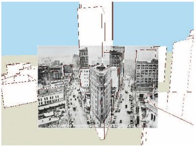
4D Cities is essentially an engineering project. “There’s a lot of math behind the scenes,” says Schindler, translating the computational analysis and computer programming into layperson terms. The number crunching begins once the photographs are scanned into the system. The program then outlines each structure in the frame with identification points. It also determines the camera position in space and focal length. These steps give a rough 3-D understanding of the scene. Combined with other photographs, a “point cloud” is formed, and it becomes possible to flesh out the full spatial picture.
To add time into the model, the programmers derived a classification system for each of the points. While the entire point cloud appears in every image, each point can take on one of four characteristics: observed, missing (corresponding to buildings that don’t exist at the time of the photograph), out of view, and occluded. It is this “visibility matrix” (the programmers’ term), formed out of these points, that ultimately determines the chronological order. Or, more basically, the passage of time is understood by whether you can see the landmark or not.
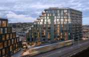
Although 4D Cities is still in the research stage, with no immediate plans for a product release, Dellaert predicts wide application of the program. It can be used by museums and historic preservation societies to access collections and by city planners and municipalities to track urban growth. Schindler, an Atlanta native, has a personal connection to the project: He’s watched the city change over his lifetime. He’s also tasked with documenting contemporary Atlanta for the database—but it’s a race to keep up with the pace of development. A building about to be razed isn’t necessarily obvious, says Schindler. “It’s hard to notice and photograph [it] before it is torn down.”
To see how Atlanta has changed over the past century and a half, experience the still-indevelopment 4D Cities Viewer at 4d-cities.cc.gatech.edu/atlanta.
Having problems viewing the image below? Try updating your Adobe Flash Plug-in by clicking here.