It was a crumbling monument that inspired the poet Percy Bysshe Shelley to pen “Ozymandias,” a musing on the inevitable decline of self-aggrandizing leaders. And it was a crumbling monument—in this case, the Buddhas of Bamiyan in Afghanistan blown up by the Taliban in 2001—that inspired engineer Ben Kacyra to form CyArk, a nonprofit based in Oakland, Calif., whose mission is to ensure that, while empires may decline, their relics will not.
Since 2003, CyArk has been using laser-scanning technology developed by Kacyra, its founding director, to record the world’s cultural and historic heritage sites in 3D. The organization wants to digitally preserve 500 projects within five years. In just over a year, it has completed about 60. The models are being collected in a free, online library whose uses include aiding educational initiatives and helping to reconstruct heritage sites—such as the torched Kasubi Tombs in Kampala, Uganda—that have been damaged by wars, natural disasters, or simply the ravages of time.
“Our mission is to digitally record and share the world’s heritage,” says Elizabeth Lee, vice president at CyArk. “Our goal is to capture as many of these heritage sites as possible, before they’re lost to the passage of time.”
Scanning the Past
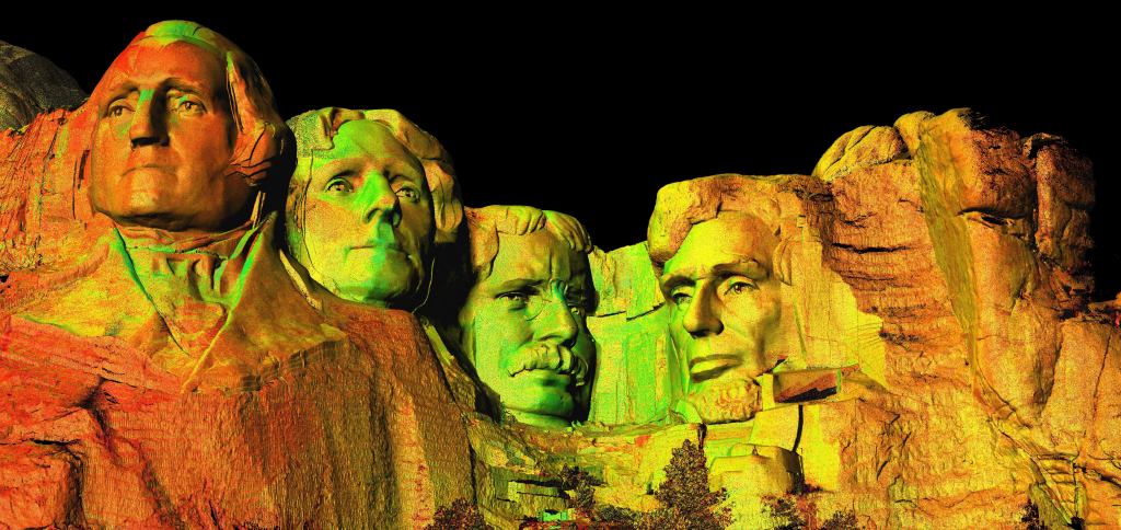
CyArk receives financial and other support from corporations, foundations, and nonprofits around the world to achieve its mission. A recent partnership is broadening the scope of CyArk’s digital archive, which contains such monuments as the Mount Rushmore National Memorial, the Tower of London, and the Washington and Lincoln memorials. Here, a global mapping and navigation company that uses similar laser-scanning technology, is giving CyArk digital data of historic districts in New Orleans and Philadelphia for archiving and use in creating its 3D models.
“We’ve just started working with the data in terms of what we can do now that we have entire cities in our archive, which is really fantastic,” Lee says, noting that CyArk will now be able to create the same types of visual experiences it does with single heritage sites on a citywide scale.
Here uses laser scanners affixed to a fleet of about 200 cars that, to date, have documented more than 300 cities worldwide. The data is used in products like Yahoo Maps and automobile navigation systems. And though it’s a bit coarser than what’s collected by CyArk—accurate to centimeters rather than to a millimeter or less, as with CyArk—Here’s data does include many historic downtowns, says Anthony Fassero, the company’s director of reality capture solutions. “It was kind of a nice win-win for CyArk and for us to donate to their cause,” he says.
The high-tech tools used to further that cause haven’t strayed too far from their source. Kacyra was the co-founder in 1993 of Bay Area tech company Cyra Technologies (now a subsidiary of Swiss surveying and geo-measurement systems firm Leica Geosystems), which developed the original, fully-integrated laser 3D imaging, mapping, modeling, and CAD system that is now used globally. To digitally preserve heritage sites, CyArk uses LiDAR (light detection and ranging) technology, in which laser beams are bounced off of a structure, monument, or other object to measure depth and distance, creating a point cloud. The CyArk team may spend anywhere from a few days to a week in the field collecting raw data, using several scanners per site, Lee says.
“From that we can create a 3D model by the process of linking these individual points together into a mesh,” she says. “The 3D model can go into rendering or animation programs. It can be used to do many things—earthquake or structural analysis, for example.” The model can also be used in gaming or augmented reality tools such as the wearable Oculus Rift, she adds.
New software that can process point clouds is making 3D laser-scanning technology more relevant to the work of conservationists. The most recent versions of Autodesk AutoCAD and Revit are capable of working with point data. And Austin, Texas–based CyArk partner Zebra Imaging, whose clients range from oil and gas to defense, has used lasers to produce holograms of several heritage sites.
Applying Lessons on the Job
Ten of the sites in CyArk’s archive, including Mount Rushmore, are the result of an initiative called the Scottish Ten, a partnership with the national heritage entity Historic Scotland and the Glasgow School of Art’s Digital Design Studio. Scotland’s five UNESCO world heritage sites have been captured along with five international sites, including a giant cantilever crane in Japan’s Nagasaki harbor.
CyArk’s Scottish collaborators have been remarkably sophisticated in their use of the data. Multiple custom and widely available visualization programs can, among other things, simulate what the heritage sites looked like in their early years, and other programs can predict the potential effects of climate change, natural disasters, and urban encroachment on existing sites. Other uses for the Scottish Ten’s data have been found in contemporary urban planning, with the hopes of one day being used to view and weigh in virtual reality the merits of new buildings proposed for urban sites, sandwiched between existing structures.
The Scottish government chose to fund the initiative, in part, for its “potential to demonstrate that cultural heritage can be cutting edge in terms of the application of technology,” says Lyn Wilson, the digital documentation manager for Historic Scotland.
Developing or using new technology that lowers projects’ overall costs remains a big priority for CyArk, Lee says. The entire process cost about $50,000 to $60,000 per heritage site when the organization started in 2003, but technological improvements have brought the figures down to $30,000 to $40,000, Lee says. The other challenges CyArk faces in capturing heritage sites with about 10 staff members remain the same. Weather can be a problem, with a blizzard delaying the Mount Rushmore project by a couple of days, and wars can make it perilous.
“We’ve sent teams, back in 2010, into [the former] Babylon in Iraq where it was still a fairly active zone, so the team had to go with security forces, and there were days [that] it wasn’t safe to travel from the compound to the site,” she says.
Of course, those challenges and others exist for anyone trying to visit these historic sites. As a result, a large part of what CyArk does serves an educational mission. The high quality of the data captured allows the information to be used in everything from simple grade-school tutorials to complex engineering studies at the university level.
Bringing it Online
One thing CyArk doesn’t do is brick-and-mortar conservation, Lee says, though its data has been used by preservationists for that purpose. In recent years, CyArk has been working to make that data, most of which is archived in a former Pennsylvania limestone mine owned by records management company Iron Mountain, more accessible. A big part of that effort has been a recent partnership with Microsoft and its Internet Explorer (IE) browser to offer immersive 3D WebGL models.
Anyone connected to the Internet via IE can click into CyArk’s 3D models and play. High-resolution photographs of each heritage site provide color information for the models, so the 3D images online look true-to-life, and their size can be manipulated without losing detail. Not all of CyArk’s data has received this treatment, but Mount Rushmore, a stepwell in India called Rani-ki-Vav, and Xochicalco, a pre-Columbian archaeological site in Mexico (below), among others, can be viewed in virtual reality.
“So much emphasis was initially on getting the data into the archive and creating that record, but now we’ve started to work a lot with teachers and educators to make this information usable for a classroom,” Lee says. “For instance, you can teach subjects like what the function of an arch is in a building through projects like the Rosslyn Chapel,” a 15th-century Gothic church in Scotland.
Collaborations with museums have also played a role in CyArk’s growing educational mission. One such museum, Ars Electronica Center in Linz, Austria, is collaborating with CyArk to offer a life-sized 3D projection, called “Deep Space,” that includes some of the sites in the nonprofit’s archive. “You walk into the space … with 3D glasses, and you’re immersed in sites from around the world, from the pyramids of Tikal [in Guatemala] to the tower of Pisa [in Italy],” Lee says.
Thanks to CyArk, some of the world’s most architecturally impressive sites are more available than ever to inform today’s students, historians, architects, and more long after their ancient builders have bowed out.