I vividly remember the time I spent as an intern architect measuring buildings. As anyone in the construction industry knows, confident designs are only possible with reliable analysis. Therefore, once a project becomes “real” enough (i.e., commitments made, contracts in place), dependable as-built drawings must be obtained.
With any new job, I would find myself (sometimes with a colleague) visiting the site with a measuring tape, clipboard, pencil, and small camera in tow. Although tedious, there is something rewarding, perhaps even therapeutic, about visiting a building and getting to know it intimately, realizing that a physical change is imminent and must be informed by good documentation.
There is not only a science, but an art to onsite measurement. While a graduate student, I recall the moment when professors Robert Mangurian and Mary-Ann Ray (of Los Angeles–based Studio Works) shared their measured drawings of Hadrian’s Villa with my class. They employed an exacting methodology, which included the use of specific measuring tools, drawing instruments of different colors, and even a particular kind of paper. The results were not only accurate archeological records, but also breathtaking works of manual drawing, endowed with their own visual potency and richness.
Today, most architects still measure and document by hand, producing an initial set of manual drawings that they subsequently translate into CAD. However, 3D-scanning technology portends impending changes in the way architects and other construction industry professionals document sites.
This technology has come a long way in recent years. Like cameras, 3D scanners collect data that falls within a particular field of view. This data includes information about relative distances, and typically results in a virtual point cloud of sample geometry that may be translated into a usable 3D model. There are many types of 3D scanners, including those that employ different types of light as well as those that require physical contact with an object.
Like most technologies, 3D scanning has become increasingly nimble and affordable. This February, MakerBot announced that its desktop Digitizer Desktop 3D Scanner would be priced at roughly $800. Those interested in measuring larger objects will be intrigued with 3D Systems’ Sense, a $400 handheld scanner that can perform a full-body scan. Collecting data of environments requires a technology like Matterport’s Pro 3D Camera, a device that can capture geometry as well as color and texture information within interior spaces up to 10,000 square feet. Available for the first time in March, the camera comes with a heftier price tag of $4,500.
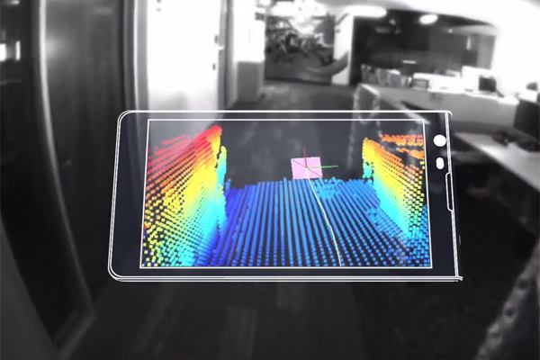
Google’s Project Tango has the greatest potential as a mobile scanning technology that architects might employ for daily site reconnaissance tasks. Tango is based on a 5-inch mobile phone prototype, a relatively tiny device that contains both the hardware and software required to collect 3D spatial data. Processing a breathtaking quarter million 3D measurements per second, Tango can be freely moved around in space to construct a virtual mirror of an environment. The technology is not yet available to the consumer, although Google has been sharing its prototypes with developers that participate in its research program. In addition to 3D mapping, Tango promises to fulfill a variety of functions including way finding, entertainment, and disaster response.
Despite the significant capabilities of Tango and other 3D-scanning tools, they are not likely to replace manual site measurement overnight. Costs aside, the current method of collecting large volumes of geometry-intensive cloud data is not the most efficient approach of 3D analysis, particularly for simple, rectilinear rooms or objects. Architects typically translate measured built spaces into a few points interconnected by line segments—perhaps not the most precise archaeological approach, but quite efficient nonetheless. 3D scanners produce measured geometry in fuzzy, unruly data-chunks as opposed to nimble wireframe models, and this data must be distilled and simplified before it is manageable.
Nevertheless, there are many cases in which 3D scanning is the preferable method. These include measuring complex interior spaces and objects; collecting a quick inventory of a large number of varied items, textures, and colors; analyzing spaces that are not easily physically accessible, such as the tall interior ceiling of a cathedral; and measuring spaces that are inhospitable, like a disaster area or otherwise hazardous environment. Beyond such applications, architects will find better luck using time-proven manual methods for quotidian tasks. However, the potential of these new scanning technologies suggests that they will eventually transform the way we document—and perhaps even perceive—the world around us.
Blaine Brownell, AIA, is a regularly featured columnist whose stories appear on this website each week. His views and conclusions are not necessarily those of ARCHITECT magazine nor of the American Institute of Architects.