If BIM (building information modeling) was the digital means by which to focus a design team around a shared object of interest—a building—CIM (which can refer to Civil Information Modeling, Construction Information Modeling, or City Information Modeling) is expanding this focus in both space and time. CIM indicates a trajectory that extends physically and temporally outward from a single building’s original construction, ultimately tracking the complex relationships between buildings, their sites, and the people and objects that occupy them.
The shift anticipates the emergence of what Shaping Things ( MIT Press, 2005) author Bruce Sterling calls the “synchronic society,” a technology-empowered community capable of tracking all physical objects in detail throughout their functional lives. “A synchronic society generates trillions of catalogable, searchable, trackable trajectories: patterns of design, manufacturing, distribution and recycling that are maintained in fine-grained detail,” Sterling writes. “These are the micro histories of people with objects: they are the records of made things in their transition from raw material, through usability, to evanescence, and back again to raw material.”
The concept is both formidable and inspiring. Although CIM is a long way from attaining Sterling’s all-encompassing vision, it has already begun to transform the space- and time-framework of construction projects in positive ways. But to fully grasp the capacity of this conceptual shift, it is critical to understand each version of CIM and their potential implications for architectural practice.
Civil Information Modeling
As the name suggests, this CIM version is tailored to the discipline of civil engineering. According to a 2014 paper by construction and engineering researchers at Iowa State University, Civil Information Modeling is like BIM but more appropriately suited to “horizontal projects,” such as roadways or tunnels. These works have qualities that are different from typical building construction projects, including site conditions that change well beyond the site boundaries and the need to coordinate traffic during construction. CIM also incorporates the use of LiDAR, a remote sensing method used to analyze the Earth’s surface, to provide virtual model information. This data, collected in the form of 3D point clouds, forms the basis of a CIM design. CIM can also be used for Automated Machine Guidance, providing detailed work information to operators of heavy equipment, such as graders and excavators.
Although digital models are more commonly found in vertical projects, civil engineering modeling is growing rapidly, particularly among transportation agencies. Some common tools include Bentley System’s Corridor Modeler, utilized by Iowa Department of Transportation, and Bentley’s Power GEOPAK, employed by the Missouri Department of Transportation. The standard exchange formats of TransXML and LandXML enable file-sharing among these different software platforms. Although civil engineering modeling is still in an early stage of utilization, its swift adoption points to the demand to expand BIM in terms of physical scope.
Construction Information Modeling
Construction information modeling emphasizes the monitoring of heavy construction in infrastructural projects. In a blog post, software company Autodesk documents Japanese construction corporation Obayashi’s successful use of the construction information modeling/management process to build the Mikusa Tunnel project along the Kinki Highway, in Japan using evit and Civil 3D platforms. As with civil-CIM, this project required the incorporation of detailed information about existing soil types, bedrock locations, groundwater levels, and other data beyond the structure itself.
The firm also utilized Autodesk’s Navisworks project-review software to pre-visualize construction phasing and adapt as necessary to changing conditions. “For example, when pouring concrete, there was data we wanted to manage on-site, such as when, how, and where it was poured,” said Obayashi engineer Shinya Sugiura in the blog post. An add-on package called Navis+, developed by Itochu Techno Solutions, enabled Obayashi to incorporate additional data, such as structural shapes. According to Sugiura, the use of construction information modeling improved project efficiency by 35 percent as compared to conventional documentation methods.
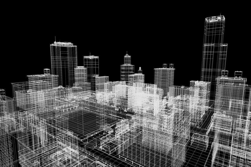
City Information Modeling
City Information Modeling is generally viewed as a fundamental tool for achieving smart cities. “BIM and the smart city are intertwined,” argues Lily Maxwell of Mülheim, Germany–based strategic consulting firm Bee Smart City in a BIM Community blog. “BIM can be seen as one smart city ‘tool’, offering huge potential to help cities deal with the challenges that growing urbanization poses through improving their operational efficiency, facilitating multi-stakeholder cooperation and cutting costs.” The concept is that a city’s digital twin enables risk-free testing of various design scenarios to tackle common challenges—such as traffic congestion, housing supply and demand, or environmental degradation—while incorporating community-based input.
Blaine Brownell, AIA, is a regularly featured columnist whose stories appear on this website twice a month. His views and conclusions are not necessarily those of ARCHITECT magazine nor of The American Institute of Architects.