It is a truism of the progressive wing in architecture as well as politics that we need to concentrate on building better infrastructure. It is also a given that we must restore and provide access to our long neglected rivers, streams, and natural watershed. Reversing decades of neglect and a concentration on cars seems logical and necessary. Using our waterways both to provide drainage and resilience at a time of climate change, while also making them into public open spaces, would seem equally a good thing. Our response to water, its lack and its surfeit, would seem the best way to argue for better infrastructure.
The problem is where such necessary proposals leave designers. Waterway restoration is nice, but it needs to be part of smart water management, and most of that work happens in invisible ways, such as by discouraging waste and providing (invisible) surge storage. Physical infrastructure is also necessary, but should we not also, and perhaps first, look at using computer and communication technologies to improve access to the disenfranchised, services at a low cost, and community building without too much fixed investment?
I was thinking about these issues when I saw the latest designs for the Los Angeles River, and my thinking was then sharpened during a discussion I had with Thom Mayne, FAIA, and Lukas Feireiss about the issue during the opening of an exhibition about Houston (“Houston: Genetic City”) at, of all places, the Aedes Architecture Forum in Berlin.
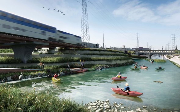
From the Los Angeles River Downtown Design Dialogue (City of Los Angeles, Bureau of Engineering). Used by Permission from Mia Lehrer and Associates
From the Los Angeles River Downtown Design Dialogue (City of Los Angeles, Bureau of Engineering). Used by Permission from Mia Lehrer and Associates
In both cases, what bothered me was the lack of connection between data, design, and a real sense of effects.
Several years ago, Frank Gehry, FAIA, embarked on an effort to map and analyze every aspect of the L.A. River for its full 48-mile length. The terabytes of material his office collected included not just the physical terrain, scanned to a resolution of several inches, but also climate, soil, and, just as important, social data such as access to public land, disease prevalence, and crime statistics. All that material is now available to the public. When the L.A. mayor asked Gehry to undertake the study, designers and activists thought that he was trying to steal control over the river and its future. Gehry said he was just trying to design data and mapping tools.
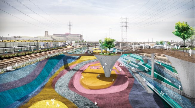
From the Los Angeles River Downtown Design Dialogue (City of Los Angeles, Bureau of Engineering). Used by Permission from AECOM
Now some of those same protesting designers, such as Mia Lehrer, have produced designs for a short stretch of the river, the results of which are perfectly fine in terms of providing access, restoring some natural water flow and vegetation, and hinting at dynamic diagonals that will shape public parks. They stop there, however, giving little hint of how this work with make a material difference in the overall ecology of the river or how it will affect the health and welfare of those who live near its banks.
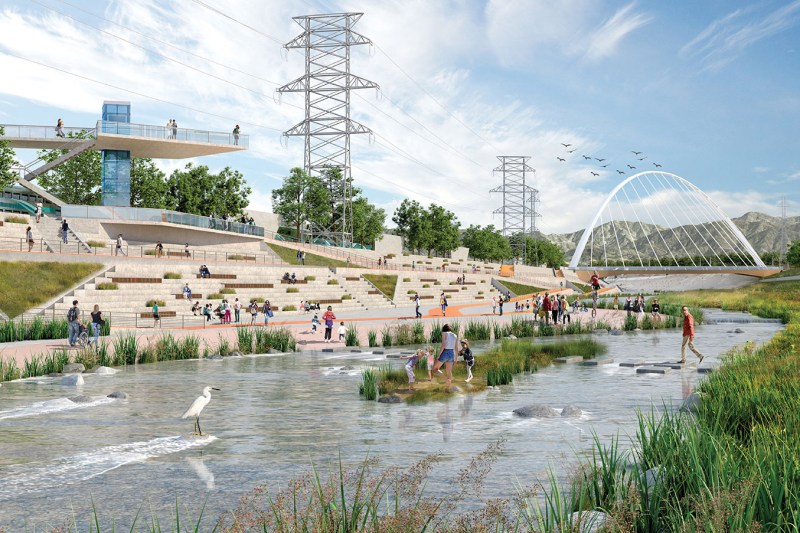
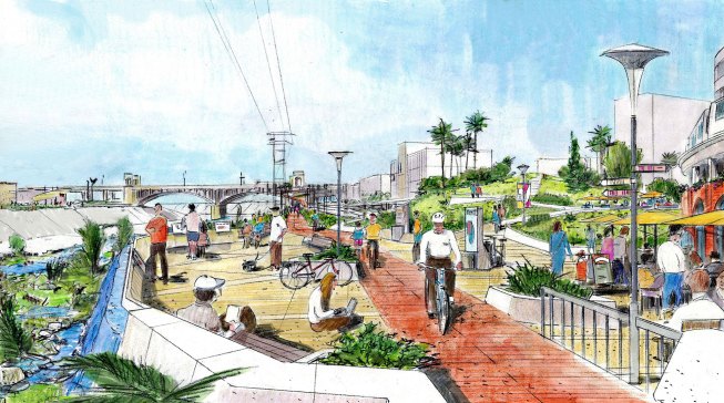
From the Los Angeles River Downtown Design Dialogue (City of Los Angeles, Bureau of Engineering). Used by Permission from Gruen Associates
At the Berlin event, Mayne argued for the necessity of thinking of architecture as starting with infrastructure. He says that he always thought of his buildings as unfolding the natural and the manmade landscape, and that he was trained as an urban designer. Mayne has taught studios and written books on L.A.’s infrastructure, and taught part of the studio at the University of Houston that was the subject of the Aedes exhibition.
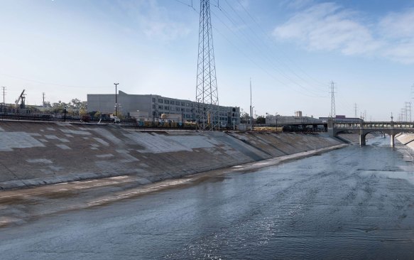
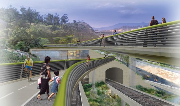
From the Los Angeles River Downtown Design Dialogue (City of Los Angeles, Bureau of Engineering). Used by Permission from CH2M
I could not disagree with Mayne on his approach, and was extremely impressed by the sheer amount of data and imagery the students had collected about Houston, which focused on the 53-mile-length of the city’s Buffalo Bayou. Their projects, however, did not always reflect this research. They presented large-scale river improvement, wetland restorations, transport hubs, and transit-oriented development.
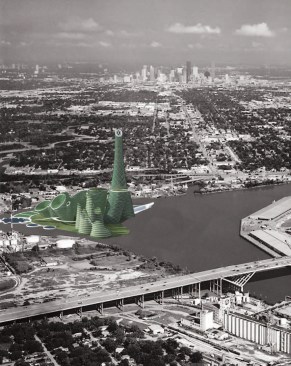
Air Island, by Michael Zepeda
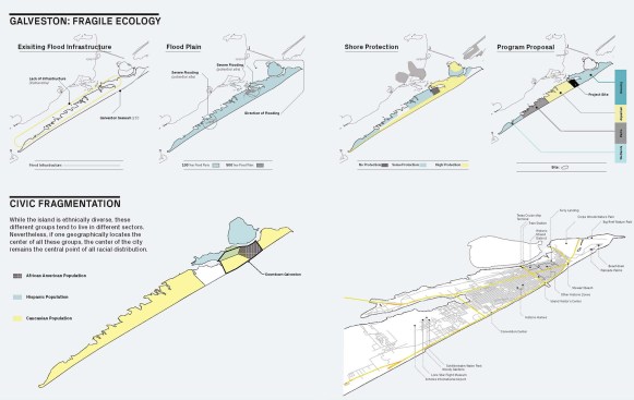
There is nothing wrong with such approaches, but someone should ask: Is the scale feasible and the investment logical? Certainly, the problems are, to quote one person who has famously claimed to want to do something about them, “huuge.” Houston, soon to be the country’s third largest city, is by far its most polluted. In addition, between sea surges coming up from Galveston and floods sweeping down its bayous, the city may soon experience catastrophic floods as a matter of course. Its social problems, from homelessness and lack of access to service to cancer clusters, are equally immense.
Courtesy University of Houston Gerald D. Hines College of Architecture and Design, Energy City Studio
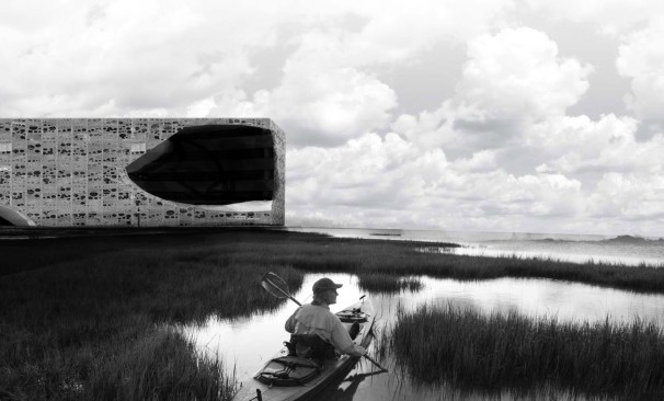
The Galveston Wetline, Wetline I, by Grant Lewis
The student solutions (before they all got sucked into the edifice complex and designed tortured towers and multi-use rhomboids) included buildings with floodable bases at the smallest scale, and artificial islands in front of Galveston to break up waves at the largest extreme. Most of their design proposals were logical and many of the renderings were beautiful. There is little chance that any of them will ever be implemented.
What Houston needs, in addition to such major works, is a restoration of wetlands, a building of catchment basins and flood remediation measures required for any new development, more green planting, a tax on gasoline, stricter pollution controls, and access to healthcare for everybody. Beyond those things, Houston needs a vision for what to do when oil and gas stop being the engine of America’s cars and growth, one that can build on the embedded technological knowledge that the carbon-based industry has produced, as well as on the skills and diversity of one of the most multicultural populations in the U.S.
Courtesy University of Houston Gerald D. Hines College of Architecture and Design, Energy City Studio
The Galveston Wetline, Wetline I, by Grant Lewis
These measures might sound utopian, but countries such as the Netherlands have shown that they can be implemented. What should also happen—both in Houston and in Los Angeles, as well as in New York and every other major city in the country—is the activation and socialization of databases and social networks so that people can gain knowledge about the conditions of their landscape, have access to healthcare, and form communities even when they are isolated by roads and industry in their air-conditioned homes and cars. All that computing power should not just be for shopping and flirting, it needs to be used to allow all of us to know our communities better and to be a part of our landscape.
Even if we could do all of this, much of it would be invisible. But rather than having that fact be a limitation, it should make us want to figure out how architecture could make such measures visible. Taking us down next to the river on sloping and planted bicycle paths would be great, but figuring out how to use, cross, contain, and activate the river would be better. As Ashley and Gunnar Hand wrote in the latest Newsletter (Summer 2017 edition, from the Los Angeles Forum for Architecture and Urban Design:
If we can use information to make cities more mobile, accessible, sustainable, and resilient, then we must use the existing information to help shape the built environment, as well as direct the information of the future by determining what data should start being collected now. As designers, we have an obligation not only to understand the potential this data can bring to our work, but to advocate for best practices to help us help our cities. We must interject our expertise and lead this conversation, which is inherently about the design of the built environment. Perhaps the public realm really is limitless …