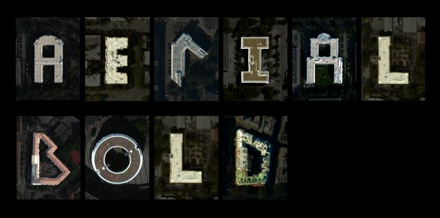
Typography lovers, cartography nerds, and architects rejoice. Aerial Bold is self-described as the first map and typeface of the earth and will be designed by scanning satellite images of the earth for shapes resembling letters in the topography—think the letter “B” formed with the intersections of buildings, road, rivers, trees, and lakes. The project’s Kickstarter was fully funded on Oct. 26, less than two weeks after it launched. The creative duo behind this project is MIT alumni Benedikt Groß, a computational and speculative designer, and Joey Lee, a geographer and digital media designer. Groß and Lee also wrote and self-published the “Big Atlas of L.A. Pools” last year, which is a summary of their findings of an analysis of Los Angeles Basin swimming pools.
With the funds raised on Kickstarter, the two designers will be able to create a complete typeface as well as an online database collecting all the information gleaned from their research. Although they have been able to identify some of the letters, they need round out a complete typeface. Additionally, the funding will help keep the metadata from all their research accessible to the public online.