Lord, Aeck & Sargent
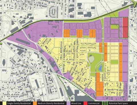
The master plan for the Belt Line includes residential, mixed-us…
Historically, Atlanta’s development is linked to the railroad. The city was established in the 1830s, with the fortunately short-lived name of Terminus, as the final stop on the Western and Atlantic Railroad’s route out of Chattanooga, Tenn. A loop of track, the Belt Line, took shape around the city to feed its rapid industrial development. While trains bolstered the commercial economy, hundreds of miles of light rail crisscrossed the city, networking downtown to streetcar suburbs. A sepia-tinged, early 20th century snapshot would reveal an infrastructural idyll.
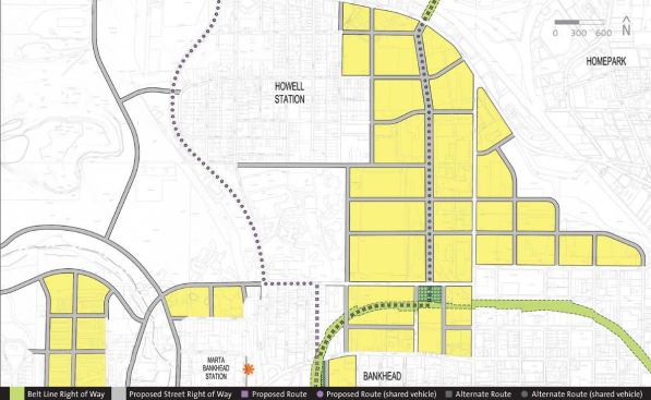
These days, traffic-heavy freeways knot sprawling, postindustrial Atlanta. Although the city’s urban core is seeing regeneration after half a century of suburban flight, still only one-sixth of the population lives within the area delineated by the now-abandoned tracks of the Belt Line. The city and its planners see potential rebirth in that 22-mile loop of historic railroad. A master plan for the Belt Line is under way: It sketches out, over 25 years, an ambitious vision that provides new parkland and light rail systems (it connects into Metropolitan Atlanta Rapid Transit Authority, or MARTA, lines) while supporting older neighborhoods and fostering development on underutilized land.
Architect David Green, a principal at Atlanta-based Lord, Aeck & Sargent, worked on the Belt Line’s street framework plan. “The plan backs into a rail system that was already in place 50 years ago,” he explains. “The primary issue is that of transit, but the overarching question is how to tie the existing neighborhoods back together. How do we bridge that gap between the tracks?”
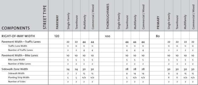
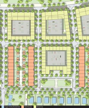
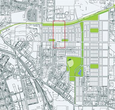
Pieces of the project are already under construction. A one-mile section is expected to open this year, and Lord, Aeck & Sargent are designing the street plan and 3,000 housing units in the Chosewood Park neighborhood. The new structures increase density but are scaled to respect typical Atlanta block sizes. The design pays close attention to parking lot sizes, sidewalks, and street alignments—details that encourage an urban feel.
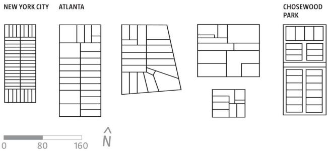
Green compares the Belt Line with the famous Commissioners’ Plan of 1811—which set the guidelines for Manhattan’s telltale grid. The Belt Line plan doesn’t mimic the orthogonal pattern of New York; in fact, it extends bits of the urban fabric locally around the necklace. But the Atlanta master plan does parallel the scale of the Commissioners’ Plan, attempting to master 5,500 acres and 45 different neighborhoods.
“It is an enormous public space, practically and culturally. If it wasn’t big and bold, people wouldn’t have gotten behind it,” says Atlanta planner Ryan Gravel, who conceived of the Belt Line project in the late 1990s as his graduate thesis at Georgia Tech. The concept took off after it reached city council representative Cathy Woolard, gaining further momentum via grassroots efforts. “It is about how public investment in infrastructure creates private goals,” Gravel explains. “People moving here expect more from an urban environment. Atlanta is a young city, and we relied on automobiles for 40 years. We are just now learning how to grow better and be more sustainable.”