Zoning isn’t glamorous. It’s not edgy like architecture or lucrative like real estate; kids don’t grow up aspiring to serve on their city’s zoning board. But just about everyone who loves cities loves zoning. “Zoning is a matter of values, ultimately,” said Raphael Fischler, director of McGill’s School of Urban Planning, during a December panel on New York City’s landmark zoning code that was hosted by the City Museum of New York. “It’s what we care about. It’s how we see our city.” Zoning matters because it is the public’s most powerful tool to shape the cityscape.
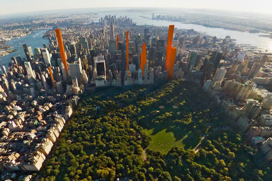
The City Museum has hosted a series of panels about controversial zoning issues as part of its yearlong celebration of New York’s code, which turned 100 last July. The museum has also curated a fascinating exhibit, “Mastering the Metropolis: New York and Zoning, 1916–2016,” which runs through April 23. December’s panel focused on the slim supertall residential skyscrapers going up along the southern edge of Central Park, which will cast long shadows, obstruct familiar views, and change the city’s skyline—as well as house some of its most expensive condos. Central Park’s southern border, 57th Street, has recently been nicknamed “Billionaires’ Row.”
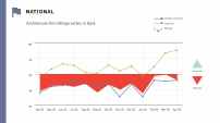
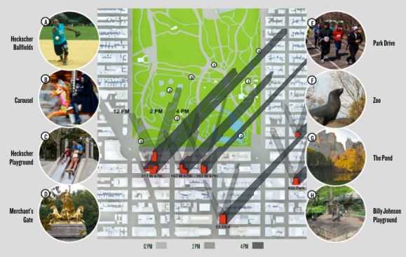
In 2013, the Municipal Arts Society (MAS), an advocacy organization and one of the panel’s co-sponsors, published “The Accidental Skyline,” a critique of supertalls (buildings taller than 1,000 feet). To better regulate those skyscrapers, the report argued, the city should consider changes to the zoning code. “Because advances in building technology allow extraordinarily tall buildings to be built on very small sites and the demand for luxury apartments make these buildings desirable investments, it is now important to consider how and where we—New Yorkers—want our skyline to continue to develop and grow,” the report says. Many New Yorkers agree. Over the past few years, they’ve flooded community board meetings, marched on 57th Street, and formed advocacy groups to protest the towers, particularly their park-darkening shadows. So far, though, the city has avoided the supertall question.
Central Park shadow projections for September 21 as published in the "Accidental Skyline" report
The Skyline as a Symbolic Reflection
The panel at the City Museum reinvigorated the debate, even though the evening was, by all accounts, subdued. Panelists took care not to talk over one another, and audience members quietly wrote questions on note cards. Many of the panelists really like supertalls. John Cetra, AIA, whose firm CetraRuddy is constructing one of them at 45 Broad Street in Lower Manhattan; Michael Sillerman, whose law firm, Kramer Levin, counsels developers building supertalls; and Carol Willis, director of the Skyscraper Museum, which has curated multiple exhibitions on the buildings, all bristled at MAS’s suggestion that they will mar the city’s skyline or make it “accidental.” “I certainly think it is surprising,” Cetra said of the changing skyline, “but accidental is the wrong terminology.” They argued that creativity and change make New York great. But other panelists noted that the conflict over supertalls intersects with a bigger debate over New York’s increasing inequality and unaffordability. A skyline is “a symbolic reflection of a society,” Fischler said, noting that the prominence of super-luxury condos makes wealth super visible. “Is this the image we want to project?” he asked. “Maybe it’s great—New York has the superrich, why don’t we show that off to the world? That’s legitimate. But not everyone agrees with it.”
In New York, zoning first emerged because of shadows. When the bulky, 40-story Equitable Building, designed by Ernest Graham, opened on Broadway in Lower Manhattan in 1915, it cast a 7.5-acre-long shadow across the financial district, triggering a commercial and political fiasco. The shadow lowered the value of nearby properties, which forced the city to lower the taxes on them. Meanwhile, the real estate industry, fearing future loses, began advocating for regulations on tall buildings.
But the Equitable Building wasn’t the only spark that fueled change. At roughly the same time, housing advocates were mobilizing to protect poor residents from the overcrowded, unsafe, dark tenements that Jacob Riis documented in his photographs of the Lower East Side. The political will to zone New York emerged from concerns over the way the city’s built environment blocked sunlight from both homes and businesses, and harmed residents’ standard of living, especially of the city’s poor. One Riis photograph shows a dim room lined with sewing machines, doubling as a sweatshop; another shows a sliver of an alleyway between two apartment buildings, a few small windows opening onto the narrow air shaft.
The 1916 zoning resolution was the first of its kind in the United States, regulating buildings’ size (or “bulk”) and use (residential, commercial, manufacturing) across an entire city rather than in piecemeal fashion. The resolution responded to skyscrapers’ shadows by codifying “the setback,” a design innovation exemplified by the Empire State Building and the Chrysler Building. City commissioners realized that tall buildings could still allow sunlight to hit streets so long as they didn’t rise straight up; regulations allowed a building’s base to rise a certain height (calculated in relation to the street’s width), before “setting-back” and creating a tiered tower. It worked, and for the next few decades, setback skyscrapers proliferated.
Since then, the city has added thousands of addendums to the code, totaling more than 1,000 pages of text, to create, among other things, more public space and more affordable housing. A 1961 zoning resolution added the conjoined concepts of floor area ratio (FAR), which reduced a building’s bulk by defining its maximum square footage, and incentive zoning, which allows developers to build beyond their defined FAR if they include an amenity like a public plaza. This enabled developers and architects to be more creative with form and height, and ensured that the city would have more public space. But it also meant that tall buildings increasingly had ugly, ad hoc plazas, like 1 New York Plaza, in the Financial District, completed in 1969 and recently identified by the city as one of many public spaces in need of upgrades.
Rob Stephenson
The 1968 Edward Durell Stone-designed General Motors Building, a 50-story project that gained extra floors because the developers also built a public plaza and arcade
In March 2016, the city added mandatory inclusionary zoning, which allows residential developers to build a bigger building if 25 to 30 percent of its units are affordable (as defined by the median household income for area).
The “As of Right” Transfer
Never has the zoning code imposed an outright limit on building heights. Instead, it employs innovations like the setback principal, FAR, and inclusionary zoning to impose nonuniform limits on how big a building can be. These regulations welcome a certain degree of creativity. If a developer buys a lot next to a building that wasn’t constructed to its maximum allowed square footage—basically, if it’s shorter than zoning requires it to be—the developer can buy these unused air rights and transfer them to his building.
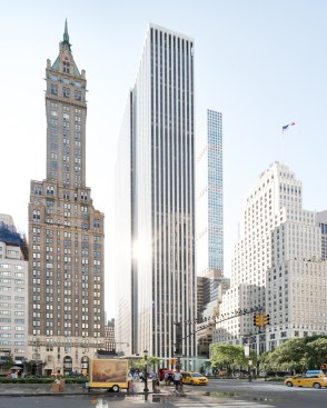
And all of this can happen “as of right,” which means that, as long as the new tower adheres to the square footage allowed by its lot plus the newly purchased air rights, the developer doesn’t have to go through any review by the City Planning Commission. Forty years ago, this meant a really tall skyscraper might rise to, say, 50 or 60 stories. When Trump Tower, on Fifth Avenue, opened in 1983 after purchasing the air rights from its neighbor, the jeweler Tiffany’s, it rose to a then-controversial 664 feet. Thanks to amazing feats of engineering, architects are building more than twice these heights today. 432 Park Avenue, completed last year on 57th Street, stands 1,396 feet tall.
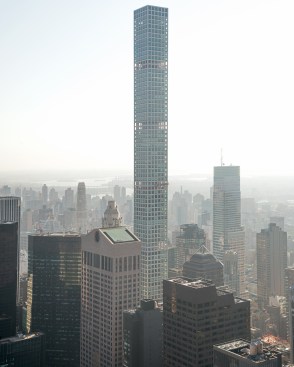
Rob Stephenson
432 Park Avenue, designed by Rafael Viñoly
Critics of supertalls argue that the city needs to update zoning regulations to respond to these unanticipated height increases, perhaps ending the use of “as of right” transfers. Zoning was never intended to streamline the construction of such projects, they say, particularly ones filling the streets around Central Park. In Montreal, new skyscrapers near parks must meet a specific performance criteria: the building must allow 8 hours of sunshine on at least 50 percent of the park. Some in New York have argued for similar zoning regulations that set specific height limits alongside important public amenities.
At the panel discussion, not everyone agreed, of course. “The great genius of New York is Delirious New York, and creative destruction,” Sillerman said. “We have had changes in scale and form before, and I think we have to be concerned about not allowing the evolution of New York.” The conflict over supertalls invokes the desire for change versus the desire to preserve, but it also taps into questions over whose rights should drive city-making: the builders and their clients, happy to pay millions for spectacular views, or the walkers and workers down below, eager to soak in a few rays?
While it’s too late for the city to do much about the shadow-making supertalls around Central Park, these slender megaliths have only just begun to change the skyline; according to MAS, areas ripe for supertall development include Lower Manhattan, Brooklyn, and Long Island City. There’s still time to figure out what New Yorkers think about supertalls and, perhaps, to add a few more pages to the century-old zoning code.