How can architects use GIS data to design holistic buildings?
GIS stands for geographic information systems. It’s an analysis and design tool that allows architects to visualize different design scenarios using layers of data in a geographic context. A site’s surrounding infrastructure, topography, environmental conditions, population density, and other key considerations can be overlayed during the design process, helping architects make better informed decisions and, ultimately, reach more sustainable, equitable, and inclusive solutions.
Ennead Lab is the research, development, and advocacy arm of the international firm Ennead Architects, which has offices in New York, Los Angeles, and Shanghai. They deploy innovative research and design tools to advance the pursuit of a just and lasting world. With GIS, “we can tell a holistic story,” says Masha Konopleva, AIA, co-director of Ennead Lab. “GIS allows us to better understand the visible and invisible characteristics of the site, its neighborhood context and the broader city that surrounds that. GIS really allows us to simultaneously interrogate layers of data in a variety of ways.” Utilizing GIS and spatial data has allowed Ennead Lab to propose project approaches that both integrate hyper site-specific goals but also begin to address the need for equitable change.
Here’s how Ennead Lab is using GIS to propose solutions to some of the built environment’s toughest challenges.
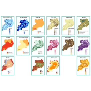
Adapting cities for people seeking refuge.
As the crisis over migration grows on a global and national scale, Ennead Lab is studying integrated design approaches for people seeking refuge or asylum in urban and rural environments. Ennead Lab and United Nations High Commissioner for Refugees developed an adaptable toolkit for site design that prioritizes mutually beneficial relationships between existing and new communities, and GIS plays a critical role. “GIS helps us to overlay a multitude of site conditions that are critical drivers for planning long-term community integration and resource management, especially as we look for more nuanced and nimbler strategies,” says Amy Mielke, an associate principal at Ennead Architects.
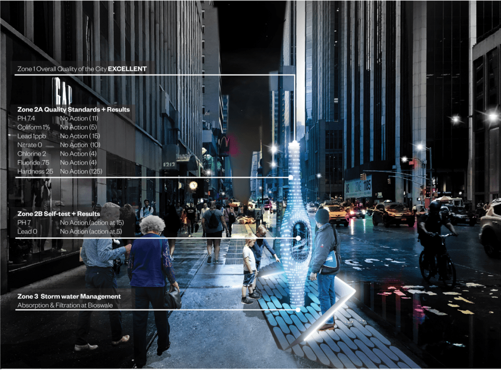
What if our water infrastructure could talk?
To build trust and bring transparency to a city’s water infrastructure, Ennead Lab proposes a solution to offer real-time information about municipal water quality. Water Alert and Testing Resource (WALTER) would place testing stations along strategic points throughout the city where people could see the water-quality results of their local water line or test samples from their faucets. Konopleva recalls the laborious task of having to physically map potential sites for sampling stations in relation to nearby schools, parks, and other highly trafficked spots, a job she can now outsource to GIS. “If we had GIS for past projects, we could have done that more quickly and rigorously,” Konopleva says.
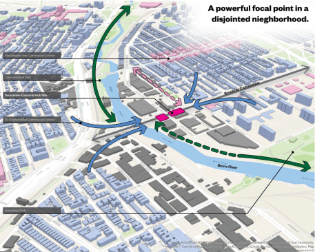
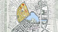
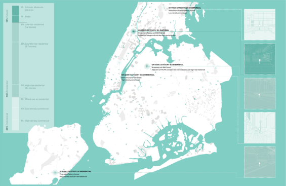
Activating underutilized spaces to strengthen and celebrate neighborhoods.
What if you could turn a vacant space underneath an expressway into a vibrant place of commerce? That’s the vision of the Soundview Economic Hub. The project, a collaboration between the Youth Ministries for Peace and Justice, the Local Center, Ennead Lab, and Public Works Partners, will kick off with an art installation that the groups say will “honor the history of self-determination in the Bronx.” Ennead is leveraging GIS to learn about community assets, site accessibility, and land use, among other critical considerations. “It’s a small site within a large context but it could have so much impact,” Konopleva says.
Ennead uses the ArcGIS system from Esri, the global leader in GIS software and mapping providing location intelligence to professionals in the AEC industry. Click here to learn more.