
See all of the 2018 winners of the Studio Prize.
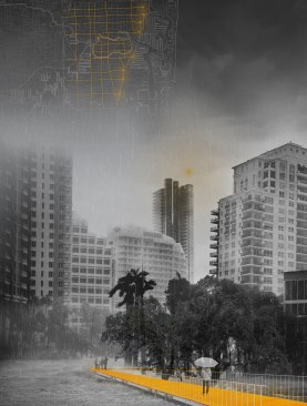
Studio Brief | Tackling the challenges of climate change in one of North America’s most environmentally vulnerable regions, students did a deep dive into the geography, urban development, and building codes along Florida’s Atlantic Coast, concluding with a set of long-term strategies for dealing with a changing climate, increasingly erratic weather, and rising sea levels.
Investigation | In 2010, four coastal counties in the Miami area united in a compact to address the growing threat of climate change. But, argues University of Toronto assistant professor Fadi Masoud, they’re stuck using outdated zoning codes that assume a static environment and offer few checks on development.
“The landscape there is dynamic, but the planning is very status quo,” he said. “Why isn’t there a better way to think about how the landscape affects where you can build, and how that changes over time?”
Working closely with government planners in Broward County, north of Miami, Masoud charged his students with a three-part task: create a dynamic GIS (geographic information system) map of the region to understand where rising water levels will have the most impact; study the current zoning tools and their limits, interviewing county officials during a weeklong visit to the area; and finally, develop a design response.
The responses, which the students presented to Broward County representatives who visited Toronto, ranged from a “freshwater credit” system that incentivizes residents to capture excess rainwater in cisterns on their property to a “flux” zoning code that changes as rising sea levels impact land-use patterns around the county. Yet another proposal considers the county’s western border, which abuts the Everglades wetlands, more as an inland “coast,” with recreational and tourism possibilities, and less as a site solely for real estate development, which might leave the area more vulnerable to sea level rise. Juror Jennifer Yoos, FAIA, lauded the students’ approach to “rethinking how these design processes should be done.”
This was the fourth time Masoud has led a hands-on, pragmatic studio focused on South Florida, and Broward County officials say it was the first time their office had worked with such a studio on planning ideas. They say they welcomed the outside insight, and have begun to incorporate some of the students’ ideas, like flux zoning, into their long-range planning.
Masoud chalks up the success to the intense site visits and the close cooperation with county officials. “I continue to be surprised at how important it is to actually meet the people in charge, and see that they are just as excited to see what an academic design studio can do.”
Student Work |
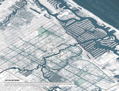
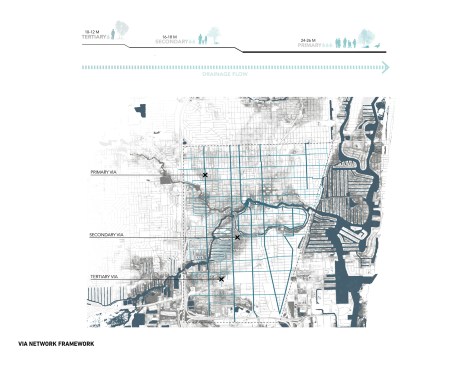
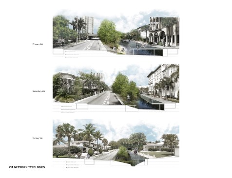
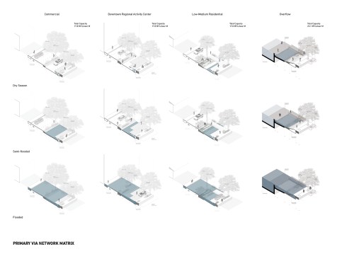
The Via Network
Marianne Lafontaine-Chicha and Niloufar Makaremi address the sunny day flood phenomenon in South Florida by envisioning new infrastructure for Ft. Lauderdale. These floods are caused by high tides that are only getting worse: A University of Miami study found that such flooding has increased 400 percent since 2006. A proposed network of “Vias”—a cross between a street and a canal—would be able to mitigate floodwaters during tidal floods, as well as create an alternative transit network, add green space and vegetation canopies, and provide additional evacuation routes in case of storms.
Marianne Lafontaine-Chicha and Niloufar Makaremi
Marianne Lafontaine-Chicha and Niloufar Makaremi
Marianne Lafontaine-Chicha and Niloufar Makaremi
Marianne Lafontaine-Chicha and Niloufar Makaremi
Marianne Lafontaine-Chicha and Niloufar Makaremi
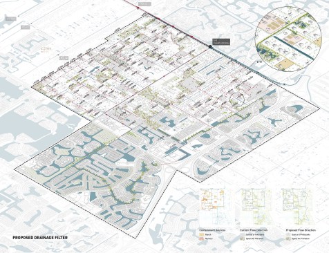
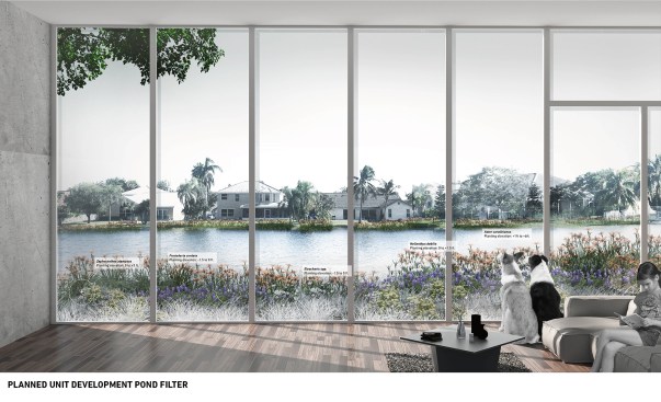
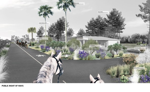
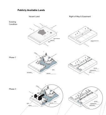
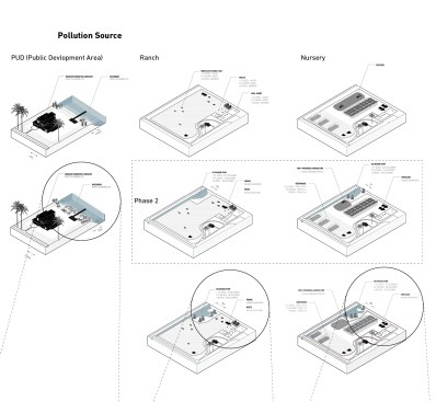
The Drainage Filter for the Everglades: Imagining a New Basin S-8
Qiwei Song, Meikang Li, and Chaoyi Cui have envisioned a way to make suburban and exurban communities a major factor in the restoration of the Everglades, by creating a toolkit of topographic and phytoremediation strategies for manmade infrastructure to filter pollution out of stormwater runoff. By rethinking the grading and vegetation of open spaces, as well as encouraging voluntary participation from private landowners, the students envision a network of channels—bringing more water into urban areas—that would make a functional green landscape, lengthening the distance between sources of runoff and the Everglades, and naturally filtering the water along the way.
Qiwei Song, Meikang Li, and Chaoyi Cui
Qiwei Song, Meikang Li, and Chaoyi Cui
Qiwei Song, Meikang Li, and Chaoyi Cui
Qiwei Song, Meikang Li, and Chaoyi Cui
Qiwei Song, Meikang Li, and Chaoyi Cui
Qiwei Song, Meikang Li, and Chaoyi Cui
Qiwei Song, Meikang Li, and Chaoyi Cui
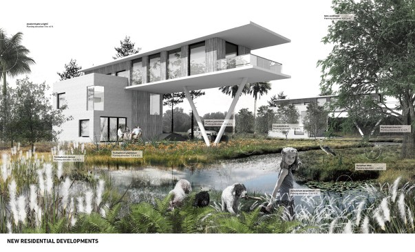
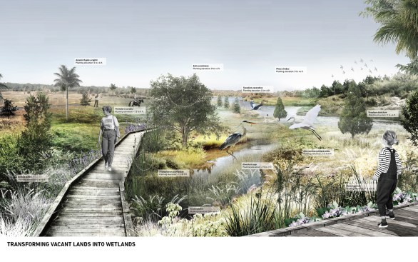
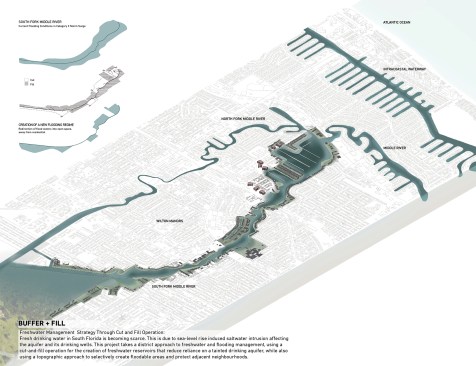
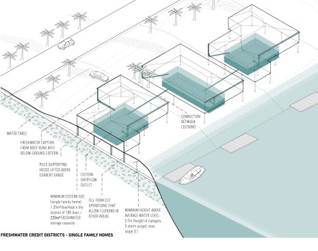
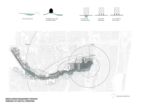
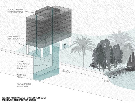
Buffer + Fill: Freshwater Credit District Plan
Leslie Norris and Natalie Schiabel address freshwater scarcity in South Florida with their plan to employ cut-and-fill techniques that would both protect property from flooding and create a network of freshwater storage basins. A series of berms would redirect water to floodable parkland from residential areas prone to flooding during a Category 3 hurricane. Within the berms, a series of networked storage tanks create neighborhood-scaled infrastructure that could manage, dispense, credit, and exchange the fresh water—turning the hazard of too much rain from increasingly frequent storms into a benefit for the community.
Leslie Norris and Natalie Schiabel
Leslie Norris and Natalie Schiabel
Leslie Norris and Natalie Schiabel
Leslie Norris and Natalie Schiabel
Studio Credits |
Course: Coding Flux: In Pursuit of Resilient Urbanism in South Florida
School: University of Toronto, John H. Daniels Faculty of Architecture, Landscape and Design
Level: M.Arch. without pre-professional degree, year three; Master of Landscape Architecture, year three; Master of Urban Design, year three
Duration: Fall 2017 semester
Instructors: Fadi Masoud (coordinator, assistant professor), Elise Shelley (assistant professor)
Students: Chaoyi Cui, Marianne Lafontaine-Chicha, Meikang Li, Niloufar Makaremi, Leslie Norris, Natalie Schiabel, Qiwei Song (submitted projects); Zainab Al Rawi, Meng Bao, Chukun Chen, Mengqi Dai, Jessica Guinto, Tania Hlavenka, Joshua Kirk, Alexandra Lazaervski, Ning Lin, Aidan Loweth, Carlos Portillo, Rayna Syed
Techniques/Tools: animated analytics (GIS, Adobe After Effects, CNC milling); codification workshop (Adobe Creative Suite, After Effects, Rhinoceros 3D); design strategies (Rhinoceros 3D, Adobe Creative Suite, After Effects)